|
|
from
Chapter 5: A Window Onto the Cosmos
(Please
be patient while graphics are loading.)
Carving the Cosmos: A Petroglyphic Solstice Marker and
Earth/Star Map
At Homolovi, Arizona
by Gary A. David
Copyright
© 2000 by Gary A. David.
 |
Across
ocher and salmon colored sandstone a shadow crawls like a shallow pool of water
flowing in slow motion. Its fuzzy penumbra gradually slides over the spiral
petroglyph pecked into smooth rock. We know this movement is the result of the
greater spinning of our planet in relation to a stationary sun. However, for
the Hisatsinom (a.k.a. the Anasazi) shadows were animate beings whose movements
reflected those of the Underworld spirits. The shadow, the voice, the face,
and even the will of the dead may cling to the living. They thus may be thought
to exist in a spirit world.
1
The
Pueblo people conceived of the spirit world as being coterminous with the chthonic
zone of the previous Third World, accessed primarily through the Sipapu
at the bottom of the Grand Canyon just east of the confluence of the Colorado
and the Little Colorado Rivers. Thus, the duality of light and dark, day and
night, summer and winter, etc. inherent in the Hisatsinom cosmology was infused
with an animism that allowed the great sun god Tawa
to interact with the lesser dusky revenants who periodically return from the
subterranean realms via the various manifestations of the Sipapu. For
us the importance of such a natural phenomenon is mostly esthetic, exemplified
by lavish Sierra Club photography depicting shadows which play across sensuously
curving sandstone sunlit in stark, vibrant colors. For the Ancient Ones, however,
shadows were
supernatural
'shades'
imbued with a mysterious vitalism that imparted not only beauty in the eye of
beholder but awe as well. The play of sunlight and shadow along a wall in a
room or across a landscape may deeply interest or even visually thrill us, but
for a people who live by the sun and depend heavily on it for knowing the seasons,
the day, or the time, the interaction of light and shadow takes on a much deeper
meaning. For them, displays of light and shadow may extend into the realm of
the sacred; they constitute a sacred appearance, or hierophany (from the Greek
words hieros, sacred and phaino, to reveal or make appear.
2
Four major ruin sites and a few outlying sites exist in
the vicinity of Homolovi
Ruins State Park near Winslow, Arizona. On the east side of the Colorado
River we find Homolovi I and II; on the west side of the river are Homolovi
III and IV, all settled at slightly different periods. Homolovi
IV, a 150 room masonry pueblo built in a stepwise manner on the east and
south sides of a small butte as well as on its top, was the settled in A.D.1260
by immigrants from the Hopi Mesa region. It was occupied only for a period of
twenty years, which might have been the result of an influx of clans moving
from the south to build some of the other sites at Homolovi.
3
A half mile south and nearer to the Colorado River, Homolovi
III was a 50-room pueblo with three rectangular kivas and one masonry great
kiva built in A.D. 1280 at about the time of the abandonment of Homolovi IV.
Because of the style of ceramics found --black-and-white painted on red ware--
plus the larger room construction of masonry and puddled adobe 4,
archaeologists hypothesize that the builders of this pueblo were Mogollons who
migrated from the Silver Creek region of eastern Arizona near the contemporary
towns of Snowflake and Showlow. As with Homolovi IV, this pueblos life span
was brief; it was abandoned in the early 1300s due to the extensive flooding
which followed the Great Drought of 1276-1299, the earlier event perhaps partially
causing the migration to Homolovi III in the first place.
On the eastern side of the Little Colorado River the comparatively
large, 900 room pueblo of Homolovi
I was begun in 1280 at about the same time as Homolovi III and perhaps
assimilated some of the people from the abandoned Homolovi IV. Some portions
of Homolovi I were two stories high, and it also contained a number of open
plazas and kivas.
One of the latter measuring fourteen feet wide and twenty feet long was paved
with flagstones and had a stone bench on the south end and a number of loom
holes on the east and west sides. This highly stratified pueblo which used a
variety of masonry and adobe construction styles suggests much renovation during
its relatively long history. It was abandoned in circa A.D. 1390 after a period
of massive flooding.
About three-and-a-half miles north on a low knoll rests Homolovi II, the largest
ruin in the area with over 1200 rooms, 40 kivas, three large plazas, and a ramada
three-hundred feet long on the south side. Beginning construction in A.D. 1330,
it gradually became the focal point of the trade network in the region. This
pueblo was also the center of the katsina
cult that developed in the late thirteenth century. In addition to numerous
representations of these spirit beings on ceramic bowls and petroglyphs, two
beautifully painted murals were found on the walls of two separate kivas at
Homolovi II: one depicts the San Francisco Peaks where the katsinam
live, while the other shows two katsina dancers with cotton kilts. Homolovi
II was abandoned at about the same time as Homolovi I near the end of the fourteenth
century.
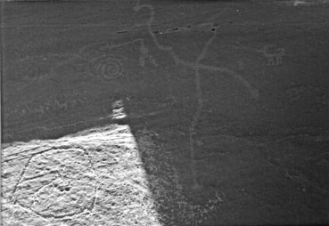
We can imagine members of the first village settled at Homolovi gathering before
dawn on the summer solstice in an alcove-like enclosure of rock not far from
their pueblo. Here they await the sacred interplay of shadow
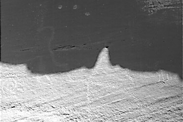
and sunlight. The main panel,
which faces eastward, is created by a vertical sandstone fault about twenty-five
feet long and fifteen feet high. It is capped by an overhanging slab that extends
horizontally about four feet to
the east. Approximately ten feet to the east is
a round-topped boulder that forms the inner east wall of the enclosure and casts
a curved shadow upon the main panel. Open to the south but blocked to the north
by broken chunks of rock heaped higher than their heads, this enclosure protects
the observers who sit cross-legged and close together on the ground, gazing
in rapt attention at the primary grouping of petroglyphs on the main panel.
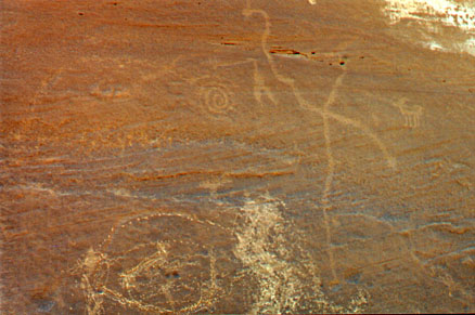
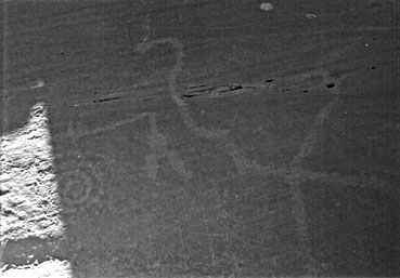
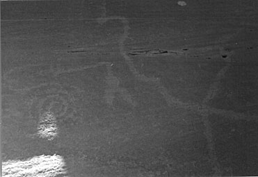
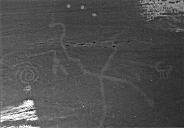
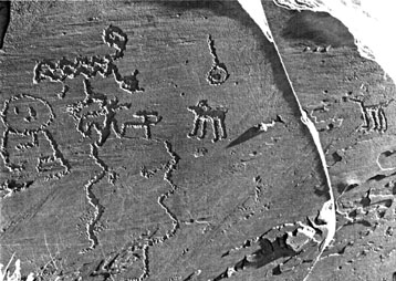
On
the left (south) side of this panel near the bottom are clan markings. These
include a bear print, a human left hand print, possibly a badger claw (all arranged
horizontally), and a snake glyph looping horizontally above these (photo upper
left).
Just
to the right of this grouping is a long migration line that curves upward and
to the right, ending in a spiral comprised of four revolutions. Near
the bottom of the panel immediately to the right of this "trail"
is a somewhat circular "corral" that contains a zoomorph in profile.
Its head faces obliquely upward and to the right. In between the trail and the
left side of the corral is a vertical zigzag snake, while on the left side is
a pair of similar zigzag
snakes,
all of which have recently
been
defaced. Slightly above and
a few inches to the right of
the
spiral is a glyph depicting some sort of V-shaped "artifact" pointed
downward. To the right of this we find a large equilateral cross formed by an
oblique axis we shall call the "plumed serpent," carved from the top
left to the lower right of the panel. A "vertical axis" bisects this
oblique line and extends downward to nearly the same height as the bottom of
the corral, ending in a cupule about one inch in diameter. To the far right
(or north) at the same height as the center of the cross, there is a petroglyph
of an antelope-- a pronghorn in profile with its head facing to the left. Viewed
as a composite, these petroglyphs are about eight feet long.
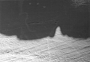
The sun priest's low,
plaintive chant mingles with pungent smoke of juniper
leaves smoldering on a chill desert wind. About
5:15 a.m. the upper arc of the suns disk flows
like molten gold over the edge of the world. Within a few moments orange sunlight
bathes the top of the main panel, while the eastern wall of the enclosure begins
to cast a gently arcing, horizontal shadow. Soon this shadow-being starts to
crawl down the panel, passing consecutively
through a number of petroglyphs: the head of the
plumed serpent, the center of the spiral, the V-shaped artifact, the intersection
of the cross, the antelope, the corral, and the clan petroglyphs on the far
left. One section on this generally horizontal shadow has two right angle jogs
that first nestle the plumed serpents head as they pass through and then follow
the slight curve on the upper portion of the vertical axis.
This progression has already taken over an hour when the shadow finally touches
both the cupule at the bottom of the crosss vertical axis and the beginning
of the trail at the lower left. The horizontal shadow continues downward for
another half hour, after which it finally leaves the panel altogether. Chants
to both the sun god Tawa and the chthonic spirits accompany this sacred appearance,
as an aura of the miraculous pervades the gradually warming air of morning.
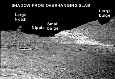
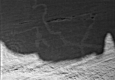
Just
as this shadow creature is departing, another one formed by the overhanging
slab begins to proceed down a yet unmentioned pair of vertical rows of dots
which are located at the very top right of the panel. Each row contains either
twenty or twenty-one pecked dots, but erosion now makes it impossible to determine
the exact number. Because of the irregularities on the edge of the horizontal
slab overhead, its adumbration has a number of bumps and notches that interact
with
specific petroglyphs during
various stages of the spectacle. (See Diagram 1 below.) In comparison with the
former shadow discussed, this one will create a dynamic synergy of sunlight
and shade that staggers the mind. Not unlike a written account of the movements
in a ballet or --more germane to our discussion-- the ritual acts of a katsina
dance, any description of this presentation is bound to fall short of its actual
intricacy and sanctity. In other words, the plays the thing.
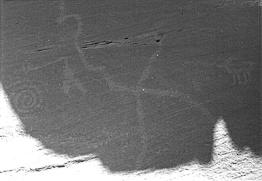
For about an hour and forty-five minutes the large bulge on the right side
of the shadow has been inching down the two vertical parallel
rows
of dots. At 8:45 a.m. as it reaches the bottom of these rows, the small bulge
is poised directly above the antelope, the nipple rests above the vertical
axis, and the large notch hovers above the head of the plumed serpent.
Nearly an hour later
the horizontal section of the shadow to the right of the large notch bisects
the antelope, while the
horizontal section to the left bisects the V-shaped artifact. At
this point the notch itself is lodged on top of the vertical axis.
After
five minutes this same horizontal section to the right reaches the feet of the
antelope, while the horizontal section to the left touches the lower tip of
the artifact. Simultaneously, the lower left side of the notch is almost at
the center of the cross. In addition, a smaller notch which has formed to the
left of the larger one is lodged between the artifact and the spiral. Furthermore,
the curving shadow to the left of this smaller notch grazes the upper part of
the spiral.
In
seven minutes the left side of the shadow reaches the center of the spiral,
and the large notch begins traveling down the lower part of the oblique plumed
serpent.
Approximately
twenty minutes later the large notch reaches the end of the plumed serpent,
while the left side of the shadow touches the outer left curve of the spiral,
where it will remain for nearly two more hours.
As the small notch begins traveling down the bottom part of the vertical axis,
the left side of the large notch touches a small cupule located at the tail
of the plumed serpent. (it is now 10:40 a.m. As the reader may have noticed,
the suns ascension causes the shadow to move generally from the upper left
to the lower right of the panel.)
After
about another half hour, the horizontal lower edge of the whole shadow has moved
off the panel, though its left side still rests on the left side of the spiral.
Around noon the shadow which has obscured the spiral since around 10:00 a.m.
begins to move again, back though its rings toward the right.
Thus far, we have been dealing primarily with shadow against stone. Now another
element enters into the play. Near the top left side of the whole shadow, a
triangle of light forms. A few minutes after noon this triangle begins to move
downward toward the spiral. At about 12:30 p.m. this triangle splits into two
smaller triangles of light. When these lights pass directly into the center
of the spiral, however, they merge.
This
one triangle proceeds downward and passes out of the spiral, where it again
splits into two smaller triangles of light. The left side of the whole shadow
is now
passing
through the corral, the only time it is obscured.
Thus
far we have been witnessing an unequivocal hierophany. For approximately seven
and a half hours we have seen the worlds of shadow and sunlight interact with
amazing complexity, evoking beyond a doubt the discernible presence of the divine.
But while the bottom of the shadow touches the bottom of the corral, and with
most of the main panel no longer illuminated, something startling occurs. Just
when we think that the sacred show is over, the light leaves the main panel
and leaps across to the smaller panel opposite it, i.e., the inner east wall
of the rock enclosure. A crescent of light with down-turned cusps hovers over
a petroglyph representing an artifact comprised of four crescents arranged on
a vertical shaft. At its top is a small circle, and just beneath that is a crescent
with upturned cusps that mirrors the crescent of sunlight with breathtaking
congruence.
 |
 |
|
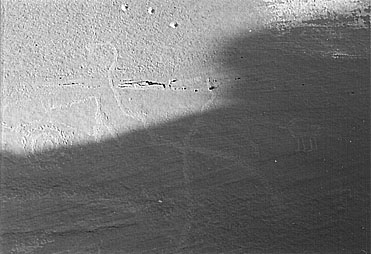
On
a smaller panel opposite main panel, a vertical artifact with perpendicular
crescents.
|
After
sunlight leaves the main panel, it hovers over top crescent of artifact.
(Petroglyph dampened to accentuate features.)
|
This
artifact is located directly across from the V-shaped artifact on the main
panel. To the right of the former artifact is a zoomorph which is also directly
across from the one inside the corral on the main panel. To the right and
a few feet below this animal on the smaller panel is a double rainbow with
a dot in the middle, which is across from the clan markings on the main panel.
At about 1:00 p.m. when the sunlight has left the main panel altogether, a
serrated shaft of light on the smaller panel advances from the lower left
toward the double rainbow on the lower right. It ultimately reaches the dot
at the center, as the whole panel is bathed in the luminous power of Tawa.
Between the droning chants of the sun priest and his offerings of corn meal
and paho feathers, he has been explaining to the people of the village the
subtle ritual performed jointly by the sun god and the Underworld spirit shadows.
Now on this longest day of the year when Tawa again begins his southward journey
along the sunrise and sunset horizons, the balance of the world is once more
restored.
What
is the significance of all this iconography vis-à-vis the interplay of dark
and light? Let us discuss the discrete elements of this configuration of rock
art, looking at the cultural symbology of each separate petroglyph.
When first viewing this group of petroglyphs, the eye
is immediately and instinctively drawn toward the spiral, which is the latters
primary function. This inward swirling form creates the illusion of three
dimensional space into which the perceivers eye is pulled, whirling toward
the mysterious and transcendental realms of the spirals eye. Some believe
that the spiral represents the shamans tunnel or portal though which spirit
journeys are made. The most frequent use of the spiral was to illustrate
emergence or vortex travel from one level of existence to another. 5
In
the context of Pueblo culture this would signify the passage via the sipapu
between the Third and the Fourth World. It is easy to imagine why the spiral
would also be associated with whirlpools in water and whirlwinds in air. Polly
Schaafsma, an expert in the field of rock art, has given a number of interpretations
for this ubiquitous petroglyph of the Southwest: ...it may symbolize water
or wind, or have an association with the sun, especially if the rock art is
positioned so that it interacts with a beam or shaft of light. To modern Hopis
and Zunis the spiral represents migrations. 6
This latter comment is especially true if the end of the spiral is extended
into a trail, which is precisely the case of the spiral at Homolovi we
have discussed. This is connected to a very long, curving path that terminates
at a number of clan petroglyphs, in particular the Bear, the Snake, and perhaps
the Badger. The loops of the spiral are also thought to represent the number
of rounds or pásos made in ancient migrations to each of the four directions.
7 One interpretation
closely associates this petroglyph with a primary Hopi deity: ...counter
clockwise spirals are reported to symbolize the path of Masau (Maasaw) bringing
rain and members of Chief kiva form (a) spiral at Winter Solstice... 8
(As the Hopi god of the earth, death, and the Underworld, Masauu
plays a significant role in the December solstice ceremony known as Soyal.)
One source geographically particularizes the symbology of the spiral by relating
it directly to the Sipapu in Grand Canyon and the Hopi salt gathering
ceremony performed there. Close to this deposit [of salt] the river forms
a series of eddies which is supposed to mark one of the entrances to the house
of Masau, and in these eddies the Hopitus, when they go there
to gather salt, toss their breath feathers and [corn] meal offerings to Masau.
9 Thus, in this context the spiral/whirlpool
is known as the gate of Masaus house. This is an important element
in constructing the stone map, the solstitial aspects of which are described
earlier in Chapter 5 (not shown).
Another element crucial in our conceptualization of
this Homolovi petroglyph grouping as a cartographic representation is the
large equilateral cross to the right of the spiral. Of course, small equilateral
crosses represent stars, but this larger one could be construed as a modified
swastika, a common symbol in Anasazi, Sinagua and Mogollon iconography for
the land, especially the center of the land. 10
We
can now see that the complete pattern formed by the migrations was a great
cross whose center, Túwanasavi [Center of the Universe], lay in what is now
the Hopi country in the southwestern part of the United States, and whose
arms extended to the four directional pásos. 11
One intriguing variation of the Homolovi cross can be found in its oblique
axis, which we have labeled the plumed serpent. In the Pueblo frame of reference,
snake iconography represents rivers in particular and water in general-- perhaps
in part because the reptilian resembles the riparian morphologically. The
snakes undulations also suggest the pattern of lightning, and the snake strikes
swiftly, as lightning strikes. 12 If
the Anasazi/Hisatsinom were lucky (or more correctly, punctilious in regard
to their ceremonial cycle), lightning was accompanied by copious amounts of
rain. As the northern equivalent of the Aztec god Quetzalcoatl or the Mayan
god Kukulkan, the plumed (or horned) serpent, called Palulukang by the Hopi,
acts as a guardian of underground springs. 13
Furthermore, it serves as a universal provider, offering its bounty in a land
of scarcity. It is a great crested serpent with mammae, which are the source
of the blood of all the animals and of all the waters of the land. 14
This hybrid creature unites the three planes of subterranean, terrestrial,
and celestial by its corresponding characteristics of reptile, mammal, and
bird. Especially in the desert the serpent symbolizes liquid life itself,
either as an indispensable potable substance (i.e., the primordial milk of
existence) or as a vital fluid flowing through the veins of all beasts.
If we orient the elements of the Homolovi petroglyph
to various geographical and human-made features of the landscape, a precise
map of the southwestern edge of the Colorado Plateau begins to take shape.
The center of the equilateral cross, of course, corresponds to Tuuwanasavi,
the "Center of the World," or the Hopi Mesas.
At the upper end of the vertical axis is a natural hole in the rock over which
a somewhat eroded but recognizable small equilateral cross has been abraded.
This correlates to the ruins of Betatakin and Kiet Siel in Tsegi
Canyon within the borders of Navaho
National Monument due north of the Hopi Mesas.
Approximately the same number of inches below the intersection point, just
to the right of the vertical axis, is a faint
mark in the rock that represents Homolovi itself. If the Hopi Mesas were
indeed first settled circa A.D. 1100, then the Hisatsinom living at this spot
where the petroglyph is located would have certainly recognized the well-established
Center-place off to the north, since this first settlement at Homolovi is
dated A.D. 1260. Incidentally, Betatakin and Homolovi are equidistant on
this north-south axis and were built at about the same time.
As we have shown, the oblique axis of the petroglyph
forming a plumed serpent represents water, specifically the Little Colorado
River that snakes from the southeast to the northwest and joins the Colorado
River at the Grand Canyon. To the right on the lower portion of the oblique
axis is an incised mark in the rock just above the extended length of the
serpent. This represents the Canyon de Chelly
pueblos, the construction of which began in A.D. 1060 between the supernova
explosion (1054) and the eruption of Sunset
Crater (1064). The
tip of the serpents tail might correspond to the ruins at Casa
Malpais and Raven
Site in
the southeast near the source of the Little Colorado.
To the left on
the upper portion of the oblique axismidway
between the intersection and the serpents head is a right angle turn that
represents the Wupatki pueblos, built
in the first few decades of the twelfth century just after the Hopi Mesas
were initially settled. Moreover, the serpent's head could be linked with
the smaller ruins of Glen Canyon along the Colorado River north of the Grand
Canyon. As an extension of the spiral, the trail roughly follows the geographic
arcing of the Colorado River as it flows downstream, terminating at a number
of clan petroglyphs, in particular the Bear Clan and the Snake Clan. As acknowledged
in Hopi oral tradition, the migration from the Third to the Fourth World entailed
the use of bamboo boats to escape a tremendous flood. Some believe that the
Hisatsinom traveled upstream and through the Grand Canyon to arrive at the
Sipapuni, at which place they emerged to seek their final destination
upon the Colorado Plateau.
Consistent with the Hermetic theme of As Above, so Below, the configuration
of pueblo villages is an analogue to the celestial plane, and the stone map
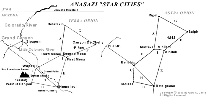
at Homolovi seems to bear this out. To the northeast Canyon de Chelly was
settled first in A.D. 1060, and its correlative star Saiph in the constellation
Orion
has a magnitude of 2.2. 15 (Although
Burnham has 2.06 for Saiph, considerable variation occurs, depending on the
source.) The three Hopi Mesas were next settled, with Shungopovi
on second Mesa established circa A.D. 1100 and Oraibi
on Third Mesa shortly thereafter (Some versions, however, state that the villages
were constructed in reverse order.) Shungopovis corresponding star is Alnilam
with a magnitude of 1.7, while Oraibis is Mintaka with a magnitude of 2.2.
Walpi
supposedly was settled in the late 1200s, but the village of Koechaptevela
at the base of First Mesa preceded the existence of the former village, so
its date of origin may have coincided with those of Shungopovi and Oraibi.
At any rate, the correlative star of First Mesa is Alnitak with a magnitude
of 1.79, approximately that of Alnilam. To the southwest Wupatki was established
about A.D. 1120, and its sidereal twin is Bellatrix, which has a magnitude
of 1.64. Thus, we can perceive the northeast-southwest axis as part of the
oblique line of the petroglyph. To the south of the Hopi Mesas Homol'ovi IV
was established in A.D. 1260, and its sidereal companion is Betelgeuse, whose
magnitude is 0.7. (However, because it is a variable star it sometimes appears
as bright as Rigel.) To the north is Betatakin, built in A.D. 1260 as well.
Its correlative is Rigel with a magnitude of 0.34. Now we can also perceive
the north-south axis as part of the vertical line of the petroglyph. The reader
may have noticed a proportional relationship between the age of the pueblo
villages and the magnitude of each villages corresponding star. Specifically,
we find that the relative age of a given ruin or extant village is for the
most part in inverse proportion to the magnitude of its sidereal correlative.
In other words, the older the village the dimmer the star. (We must remember
that a lower magnitude number signifies a greater sidereal brilliance.) To
recapitulate, the oldest villages like those in Canyon de Chelly have the
dimmest stars (i.e., Saiph), while the youngest villages like those at Homolovi
and Tsegi Canyon have the brightest stars (i.e., Betelgeuse and Rigel respectively).
Again we must decide whether or not this coincidence is meaningful. Perhaps
it is indeed another part of the elegant pattern in which the terrestrial
mirrors the celestial.
 |
Diagram
1
We
have seen how the large equilateral cross of the Homolovi petroglyph represents
both the Hopi Mesa villages at the Center-place and the ruins sites at Tsegi
Canyon, Wupatki, Homolovi, and Canyon de Chelly. This Anasazi swastika symbolizing
the land also mirrors the sky, specifically the constellation Orion. The oblique
line forming a plumed serpent corresponds to the Little Colorado River, which
flows into the Grand Canyon. We have also established that the spiral glyph
signifies the gate through which Masauu descends to his house located just
north of the two great rivers convergence. This is the grand Sipapu,
whence the people emerged onto the Fourth World where they now live. On a personal
level this is also the passage way through which the spirit will descend on
its afterlife journey. Equidistant between the plumed serpent and the spiral
is an image we have not yet discussed. A V-shaped artifact points downward,
enigmatically radiating its numinous power. If we look at a sky chart in the
region of Orion, we notice that the V-shaped Hyades of the constellation Taurus
lies adjacent to Orion in the same relative positioning that we find on the
petroglyph. The relationship between Taurus, in particular the fiery red star
Aldebaran, and Sotuknang, the Heart of the Sky God, is an enduring theme in
Hopi mythology. Hence, on this one petroglyph panel at Homolovi we unequivocally
find elements that iconographically link both the celestial and the terrestrial.
On a balance between these two forces, the forces of the sky (or the Above)
represented by Shotukünuñwa [Sotuknang], and those of the Below represented
by Palülükoñ [Palulukang], the Hopi universe rests. Symbolically, the two elements
are brought into contact in the making of medicine water [during the Snake Ceremony
in August], where the ray of sunlight flashed into the bowl signifies the Above,
and the water itself, the Below. 16 In
addition to the petroglyphic constellations of Orion and Taurus, to the left
of the V-shaped glyph is located the spiral, which perfectly corresponds on
the sky chart to the Pleiades, known to the Hopi as either Tsöötsöqam
or Sootuvìipi. 17 Thus we have
here three glyphs in a row which directly correspond to the configuration of
three major constellations.
However, the correlative factors do not stop here. To
the right of the large equilateral cross of Orion is the glyph of the antelope.
Looking to the sky chart in the same relative position, we find the brightest
star in the heavens, Sirius in Canis Major. Now, the chief continues, another
star appears in the southeast, Ponóchona [The One That Sucks From the Belly].
This is the star that controls the life of all beings in the animal kingdom.
Its appearance completes the harmonious pattern of the Creator, who ordained
that man should live in harmony with all the animals on this world. 18
We should note here that in Hopi cosmology the intercardinal direction of southeast
is totemically represented by the antelope. 19
East of First Mesa nearly 140 miles are the ruins of a grand ceremonial city
in Chaco Canyon, which is represented
in a proportional distance on the Homolovi petroglyph by this appropriate zoomorph.
Still other constellations may possibly be portrayed on
this petroglyphic star map. On an extension of the vertical line just below
a gentle curve are two abraded marks on either side of the line. The line continues
downward until it terminates in an abraded mark made inside a natural cupule.
A few inches to the right of this is another slightly larger natural cupule.
Looking at the sky chart, we find this corresponds to the rectangular constellation
Gemini. The upper pair of marks represents Alhena and Mu Gemini, while the lower
pair Pollux and Castor, known to the Hopi as Naanatupkom, or the Brothers.
20 Perhaps it is merely a coincidence,
but a natural groove in the panel cuts horizontally just below Betelgeuse and
above Alhena. Terrestrially this could correspond to the Mogollon Rim cutting
across the middle of Arizona, while celestially this might signify the Milky
Way, which the Hopi call Soomalatsi. 21
In addition, the tip of the plumed serpents tail which we said plausibly represents
the region the Hopi deem Weenima 22
(the ruins at Casa Malpais and Raven Site) may very well correspond to the constellation
Canis Minor with its bright star Procyon, known to the Hopi as Taláwsohu,
or Star Before the Light. 23
Again consulting the sky chart, we find one more constellation
represented on the Homolovi petroglyph. The aforementioned corral at first
glance appears somewhat circular, but on closer examination we find that it
looks five-sided. The Anasazi/Hisatsinom clearly had no technical difficulty
incising a perfect circle in stone, if that is what they intended. The deliberately
pentagonal figure, then, very likely corresponds to Auriga. More recently the
zoomorph inside the corral has been badly defaced, so it is difficult to determine
its species, but quite possibly it could represent a mountain goat or mountain
sheep. Having the exact magnitude of Rigel, the brightest astral point of this
constellation is Capella, which means little she-goat. 24
The zoomorph inside the corral could indeed be a mountain goat or a mountain
sheep, the latter of which is the Hopi totemic symbol for the southwest-- the
direction where the terrestrial Auriga would be located in our constellatory
schema.
Incidentally, we have already discussed the vertical zigzag
snakes on either side of the corral, which are stylistically different than
the undulating horizontal snake off to the left near the clan glyphs. The zigzag
snakes appear to be more recently incised because the re-patinization is not
as pronounced as it is on the rest of the petroglyph. In addition, these too
have been badly defaced. Initially one is enraged at such wanton destruction
of rock art, but since these zigzag elements do not seem to fit either the conceptual
configuration as we have described it or the style of the rest of the petroglyph
panel, perhaps this was an intentional defacement. Possibly some modern Hopi
tried to erase the negative spiritual effect of such spurious graffiti made
in more recent times, probably by a non-Indian. As with most rock art, a mysterious
conundrum supersedes any such speculations.
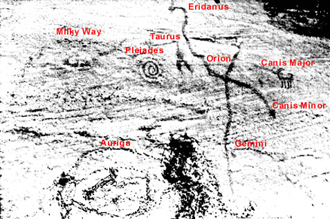
To sum up the elements of this earth/star map and solstice marker petroglyph
in terms of the supernal dimension, we have found on the panel all the constellations
of the Winter Hexagon: Orion, Taurus, the Pleiades, Auriga, Gemini, Canis Minor
and Canis Major. In terms of the tellurian dimension, represented by the large
equilateral cross are the villages of the Hopi Mesas as well as the ruins located
at Navaho National Monument, Wupatki National Monument, Homolovi Ruins State
Park, and Canyon de Chelly National Monument. What we have called the plumed
serpent represents the Little Colorado River and the on the left side of the
panel the V-shaped artifact corresponds to all the smaller ruins in the Grand
Canyon. On the right side of the panel the antelope signifies the magnificent
Anasazi/Hisatsinom ruins in Chaco Canyon. The spiral corresponds to the Hisatsinoms
Place of Emergence in the Grand Canyon, while its extension represents the Colorado
River flowing southward.
 |
|
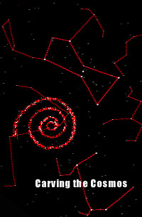
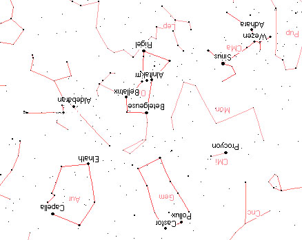
Constellations
on the main petroglyph panel proportional to the sky chart.
|
 |
|
Sky
chart rotated 180° to correlate with petroglyph orientation.
|
"Amlodhi was identified, in the crude and vivid imagery of the Norse, by the ownership of a fabled mill which, in his own time, ground out peace and plenty. Later, in decaying times, it ground out salt, and now finally, having landed at the bottom of the sea, it is grinding rock and sand, creating a vast whirlpool, the Maelstrom (i.e., the grinding stream, from the verb mala, to grind), which is supposed to be a way to the land of the dead. This imagery stands, as the evidence develops, for an astronomical process, the secular shifting of the sun through the signs of the zodiac which determines world-ages, each numbering thousands of years. Each age brings a World Era, a Twilight of the Gods. Great structures collapse; pillars topple which supported the great fabric; floods and cataclyms herald the shaping of the new world." 25
In the context of our star map petroglyph, this all seems vaguely familiar. In lieu of the marine location found in many of the mythic renditions, our desert mill located at the bottom of Grand Canyon is represented by the spiral or whirlpool. Also known as the gate of Masauu, it leads to the land of the dead. The Lord of the Mill in one variation is Saturn/Kronos 26 , who is archetypally related to the Hopi god of the Underworld named Masauu. The direction of the mill was generally thought to be northwest, ...where... Kronos-Saturn is supposed to sleep in his golden cave notwithstanding the blunt statement (by Homer) that Kronos was hurled down into deepest Tartaros. 27 At this point we probably dont need to be reminded that the Sipapu is located northwest of the Hopi Mesas.
In the variegated terms of the mythological logic so assiduously explicated in Hamlets Mill, the friction caused by the turning of the quern also produces fire at the axis mundi. 28 Masauu, earth god of fire, is translated into Orion of the (eastern) Horizon, which, resembles the firedrill or fire sticks sparking the sun god Tawa into his daily existence during the end of the annual ceremonial cycle in July. Although the Hopi Tuuwanasavi is not directly coextensive with the whirlpool of the Grand Canyon, it is contiguous, and, given the wide range of Anasazi/Hisatsinom migrations, close enough to be conceptualized as part of the Center-place.
The
recurrent image of salt in the so-called mythological implex described by
Santillana and Dechend corresponds to the destination of the salt collecting
expeditions made by the Hopi and presumably by their ancestors as well. In fact,
the Hopi term for the Grand Canyon is Oentupqa, or Salt Canyon. This theme is
related to the image of the Saltwater-Tree of the Cuna Indians who live in
Panama as well as on the San Blas Islands, and whose ancestors conceivably had
trade relations with the Anasazi/Hisatsinom Gods whirlpool is located beneath
this tree, which, when chopped down by Tapir (a sun god somewhat resembling
Quetzalcoatl), unleashes a great flood to form the worlds oceans. 29
As recalled in Hopi mythology, a mighty deluge caused the destruction of the
Hopi Third World.
According to the co-authors, the devastation of the World Tree or world pillar celestially correlates to the gradual shifting --one degree every seventy-two years-- of the vernal equinox sunrise point from one zodiacal constellation to the preceding one (hence the precession of the equinoxes), occurring once every 2,160 years and completing the full cycle once every 25,920 years. Instead of an actual tree, which is not a very potent image in the cosmology of desert dwellers, a hollow bamboo reed through which the virtuous people emerged from the lower Third to the upper Fourth World finally comes crashing down (or is cut down), leaving the wicked either imprisoned inside it or stranded below in the nether realm.
The
Norse version of the tale has an additional element found on our star petroglyph.
Corresponding to the whirlpool spiral, Hvergelmir, whose name literally means
bubbling or roaring cauldron, is the source and subsequent destination of
all the earths waters. It lies beneath the third root of the World Tree, an
ash named Yggdrasil. This root extends into Niflheim, the dark abode of the
Underworld, and is gnawed upon by Nídhögg, a flying dragon who also slowly devours
the bodies of the dead. 30 As we have
stated, the plumed serpent is represented by an oblique line on the petroglyph.
If we conflate Palulukang and Masauu/Orion, contained therein is the vitalizing
force of water and the mortuary aspect of a subterranean denizen, both of which
we find in the figure of Nídhögg. Incidentally, the harts nibbling on the shoots
of Yggdrasil could plausibly correspond to the zoomorphs on the Homolovi petroglyph.
Petroglyph found in the vicinity of the earth/star map.
On far left Masau'u as god of earth is on the same plane as zoomorphs at center and far right. Seen below, a pair of snakes with bifurcated tongues rises from the Underworld. Seen above, a pair of Palulukang figures flies horizontally through the sky, their bodies jointly forming the glyph for water. At the center a horizontal, undulating line from left to right bisects a cleft (natural?) in the rock (possibly representing the Grand Canyon) and ends with a straight line that is crossed by a perpendicular T-shaped figure (perhaps the Hopi Tuuwanasavi, or the Center of the World). Two circles, each with a straight line streaming from it and one with a dot at its center, appear to be either comets or meteors.
Santillana
and Dechend also discuss in sidereal terms the Platonic cosmology found in the
Timaeus. When the Timaean Demiurge had constructed the frame, skambha
[Sanskrit word for axis mundi], ruled by equator and ecliptic--called
by Plato the Same and the Different--which represent an X (spell it Khi,
write it X ) and when he had regulated the orbits of the planets according to
harmonic proportions, he made souls. 31
(These souls, by the way, are equal in number to that of the stars, and each
soul is assigned to a given star to which it returns after the death of the
body.) In addition to a swastikas representation of land, the chiasmic icon
of the star petroglyph might also jointly refer to the celestial equator and
the ecliptic. As heretofore stated, the former currently passes very near Oraibi/Mintaka,
while the latter always passes through Gemini, just above the right hand of
Orion and between the horns of Taurus. The precise location in the night sky
of the latter was once, a very long time ago, also the fiducial point, i.e.,
the place where the equator crosses the ecliptic. At the present this locus
is located between Pisces and Aquarius-- hence we are entering the celebrated
Age of Aquarius. However, about 6,500 years ago the fiducial point of the
vernal equinox was located between Gemini and Taurus with the Milky Way passing
directly through it. For the Anasazi/Hisatsinom this date, archaeologically
speaking, places it squarely in the middle of the Archaic period. For the Hopi
this may correspond to the First World, the pristine era of the cosmogony. For
classical writers it was the Golden Age. The 5th century A.D. Latin grammarian
and philosopher Macrobius states that during this age souls ascended through
the Gate of Capricorn and descended to be reborn through the Gate of Cancer.
32 Because of the precession of the equinoxes
caused by the slight wobble of the Earths axis, these respective gates in fact
are located between Scorpius and Sagittarius on one end of the Milky Way and
Taurus and Gemini on the opposite end. In terms of our star petroglyph the forked
icon represents Taurus (recalling the Chinese Gate of Heaven), located terrestrially
in the the Grand Canyon, which, as we have stated, is an important pathway for
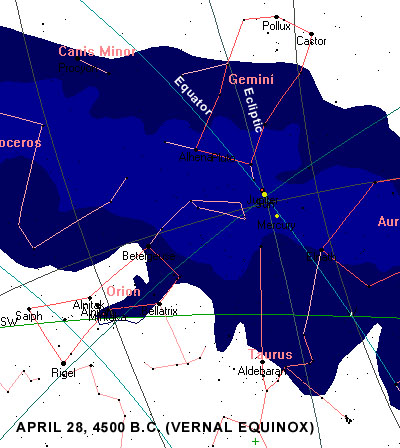
the katsinam or spirits in their afterlife journey. Thus, in 4500 B.C.
the place where the celestial equator crosses the ecliptic was at the heart
of the galactic plane. This stargate, so to speak, functioned as an interdimensional
portal through which souls could pass into this life.
 |
|
Stargate,
where the celestial equator crosses the ecliptic at the center of the
galactic plane, or the Milky Way. The green line is the western horizon.
Incidentally, on this date the Sun is conjunct Jupiter, a strongly individualistic
and optimistic aspect.
|
In
discussing our star map petroglyph vis-à-vis contemporary notions of cartography,
we must remember that the former is conceptual rather than proportionally representational.
Archaic societies were not interested in producing scale maps of either the
earth or the sky. For a rendering of mythic symbology in rock art it was sufficient
to contain merely the essential elements, as does the petroglyph at Homolovi.
That there is a whirlpool in the sky is well known; it is most probably the essential one, and it is precisely placed. It is a group of stars so named (zalos) at the foot of Orion, close to Rigel (beta Orionis, Rigel being the Arabic word for foot), the degree of which was called death, according to Hermes Trismegistos, whereas the Maori claim outright that Rigel marked the way to Hades (Castor indicating the primordial homeland). Antiochus the astrologer enumerates the whirl among the stars as Taurus. Franz Boll takes sharp exception to the adequacy of his description, but he concludes that the zalos must, indeed, be Eridanus which flows from the foot of Orion. 33
The spiral of our star petroglyph is probably closer to the left shoulder of Orion than the left foot, but the significance of the icon still remains. The Greek word zalos may be related to a combination of the intensive za- and the eleventh letter of the Greek alphabet lambda, which is V-shaped-- thus indicating Taurus and the V-shaped artifact. The great sage Hermes Trismegistus (whose Egyptian name was Thoth) states that the stars near Rigel signify death, and this is borne out in Anasazi/Hisatsinom cosmology by the glyphic depiction of the Grand Canyon, the great Sipapu. The name Eridanus literally means the river, and head of the plumed serpent could indeed represent the upper Colorado River. The plume on the snakes head extended vertically for a few feet could possibly even correspond to the Green River which flows from the north to join the Colorado River in Utah.
In
summing up the aspects main petroglyph panel at Homolovi, we find that it functions
as a multifunctional device using natural and man-made elements to produce a
dramatic interplay of light and shadow. Manifesting a stunning complexity and
beauty, this example of rock art carved probably in the late thirteenth century
serves as both a terrestrial cartography associated with the migrations of various
clans and a sky chart establishing the template of Orion and other constellations
upon the earth. In addition, it is an highly accurate solstice marker announcing
the longest day of the year when the sun god Tawa reaches his summer house on
the northeastern horizon. The purpose of the two parallel rows of dots at the
top right of the main panel is at present undetermined, but may yet prove to
have some supernal function, perhaps lunar.
For us securely ensconced in the secular world of rationalism, scientific empiricism,
and technological gadgetry, the solstice marker and earth/star map is a mute
mystery whose deeper implications have been irretrievably lost in the intervening
seven hundred years of cultural and psychological dislocations. Beyond the academic
speculations it engenders, this rock surface provides a dream screen upon which
we project our desires for a unified cosmology complete with its holistic framework
of ritual and myth. For its makers, on the other hand, the petroglyph panel
was undoubtedly a manifestation of the numinous forces inherent in a vibrant
world where the membrane between the physical and the spiritual was as diaphanous
as a breath.
Archaeological evidence shows that the average life expectancy of an Anasazi
(at least in Chaco Canyon) was a mere twenty seven years, and only five to fifteen
percent lived to age fifty. 34 On the
other hand, we contemporaries are allotted our three score and ten, which no
doubt will soon be extended by a welter of wonder drugs, nanotechnology, and
genetic manipulation. Do we not, as a result, have a tendency to look back through
the distorted lens of temporal chauvinism with some measure of pity for the
brief life span of these so-called primitive people? In an age of chaos when
Things fall apart; the centre cannot hold, 35
and the world appears to be on the brink of an absolute holocaust, are we not
the ones instead who should be pitied? The carved rock at Homolovi remains
stoically silent-- the enduring recurring rhythms of sunlight and shadow its
only refrain.
an excerpt from Chapter 5 of The Orion Phenomenon
(a work-in-progress).
Copyright
© 2000 by Gary A. David. All rights reserved
Any
use of text or photographs without the author's prior consent is expressly forbidden.
Contact: e-mail islandhills@cybertrails.com
Footnotes
1.
Hamilton A. Taylor, Pueblo Gods and Myths (Norman, Oklahoma: University
of Oklahoma Press, 1984, 1964), pp. 273-274
2. Ray A. Williamson, Living the Sky: The Cosmos
of the American Indian (Norman, Oklahoma: University of Oklahoma Press,
1989, reprint 1984), p. 92
3. William H. Walker, Homolovi: A Cultural
Crossroads (Tucson, Arizona: Arizona Archaeological Society, Homolovi Chapter,
1996), pp. 15-30
4. It is a common misconception that the Spanish
introduced adobe construction to the New World.
5. James R. Cunkle and Markus A. Jacquemain, Stone
Magic of the Ancients: Petroglyphs, Shamanic Shine Sites, Ancient Rituals (Phoenix:
Golden West Publishers, Inc. 1996, 1995), p.164
6. Polly Schaafsma, Rock Art at Wupatki-- Pots,
Textile, Glyphs, Wupatki and Walnut Canyon, edited by David Grant Noble
(Santa Fe, New Mexico: Ancient City Press, 1993, 19870, p. 22
7. Frank Waters and Oswald White Bear Fredericks,
Book of the Hopi (New York: Penguin Books, 1987, reprint 1963), p. 104
8. Nancy Olsen quoted in Sally J. Cole, Katsina
Iconography in Homolovi Rock Art, Central Little Colorado River Valley,
Arizona (Phoenix: Arizona Archaeological Society, March 1992), p. 105
9. A.M. Stephen quoted in Alex Patterson, Hopi
Pottery Symbols (Boulder, Colorado: Johnson Books, 1994), p. 28
10. This image is far older than the Nazi regime
and has a sacred rather than an malevolent connotation.
11. Waters and Fredericks, Book of the Hopi,
p. 113
12. Patricia McCreery and Ekkehart Molotki, Tapamveni:
The Rock Art Galleries of Petrified Forest and Beyond (Petrified Forest,
Arizona: Petrified Forest Museum Association, 1994), p. 16
13. Cunkle, Stone Magic of the Ancients,
p. 151
14. Alex Patterson, A Field Guide to Rock Art
Symbols of the Greater Southwest (Boulder, Colorado: Johnson Books, 1992),
p. 158
15. Mark A. Haney, Skyglobe 2.04 for Windows
[floppy disk] (Ann Arbor, Michigan: KlassM Software, 1997)
16. Richard Maitland Bradfield, An Interpretation
of Hopi Culture (Derby, England, published by the author, 1995), p. 275
17. Ekkehart Malotki, editor, Hopi Dictionary:
A Hopi-English Dictionary of the Third Mesa Dialect (Tucson, Arizona: University
of Arizona Press, 1998
18. Waters and Fredericks, Book of the Hopi,
p. 150
19. Stephen C. McCluskey, Historical Archaeoastronomy:
The Hopi Example, edited by A.F. Aveni, Archaeoastronomy in the New World
(Cambridge, Mass.: Cambridge University Press, 1982) p. ?
20. Malotki, Hopi Dictionary
21. Ibid.
22. Ibid.
23. Waters and Fredericks, Book of the Hopi,
pp. 149-150
24. Jacqueline Mitton, The Penguin Dictionary
of Astronomy (London Penguin Books Ltd, 1993, 1991), p. 61
25. Giorgio Santillana and Hertha Von Dechend,
Hamlets Mill: An Essay Investigating the Origins of Human Knowledge and
Its Transmission Through Myth (Boston: David R. Godine, Publisher, Inc.,
1998, 1969), p. 2
26. Ibid., p. 148
27. Ibid., p. 239
28. Ibid., p. 140
29. Ibid., p. 213
30. Sturluson, The Prose Edda: Tales From Norse
Mythology (Berkeley: University of California Press, 1954), p. 43
31. Santillana & Dechend, Hamlets Mill,
p. 306
32. Ibid., p. 242
33. Ibid., p. 210
34. Stephen Plog, Ancient Peoples of the American
Southwest (London: Thames and Hudson, Ltd, 1997), p. 117
35. from Y. B. Yeats' apocalyptic poem "The
Second Coming"
![]()