
|
|
from Chapter 2: The Sky Over the Hopi
Villages
(Some of this material
is also found in the Overview.)
by Gary A. David
Copyright
© 2000-2004 by Gary A. David.
The night sky over north-eastern Arizona is brilliantly clear, and Orion is a great constellation, only rivaled at this latitude by the Plough turning around the pole star to the north and by Scorpion lying low on the southwesterly horizon; but when Orion is up, it dominates the sky over the Hopi villages, both by its scale and by the magnitude of its individual stars. Richard Maitland Bradfield 1
Sacred Mountains and Boundary Shrines
Again we turn to
the land: matrix of all life rising from the dark, subterranean reservoir of
spirits; focus of all solar, lunar, and stellar energy traversing the cold,
fierce distances of cosmic night. After the arduous migration of many centuries
and the ultimate establishment of the center-place they called Tuuwanasavi,
the Anasazi
must have looked out upon the boundaries of their territory with a sense of
relief and newfound security. While the intercardinal directions of the solstice
sunrise and sunset points marked the immediate domain of the Anasazi, the living
presence of distant mountains verified the harmonic configuration of their sacred
cosmology, much as it does today. To the northwest (or more specifically, the
north-northwest) the broad, dark dome of Navaho
Mountain (10,388 ft.) reposes near the Arizona/Utah border. To the southwest
the heretofore mentioned Humphreys
Peak provides the link to the spirit world as the home of the katsinam.
Beyond the horizon to the southeast, Baldy Peak (11,403 ft.) in the White Mountains
sits on the edge of the Mogollon Rim and guards access from the south. Likewise
beyond the horizon to the northeast, Hesperus
Mountain (13,232 ft.) presides over the extensive Anasazi ruins of the Mesa
Verde region and designates the northern limit. Forming the central point of
this quincunx, the three Hopi mesas extending southwest from the pinyon-juniper
woodland of Black Mesa had served as the center of the Anasazi/Hisatsinom world
ever since they were settled and pueblo villages were built beginning circa
A.D. 1100. The Hopi still see this place as the heart of their cosmos.
Because canyons figure so predominantly in Hopi cosmology, it is possible that
the Hisatsinom
conceptualized them in the same way as they did mountains, i.e., in a directional
sense. If this is true, then the most important canyon would be, of course,
the one to the west, the Grand Canyon. The imposing Salt River Canyon would
serve as the significant gorge to the south, while Canyon de Chelly in the eastward
direction is undoubtedly the most important chasm. And finally, Glen Canyon
might serve as the directional canyon to the north. (The latter's magnificence
would still be manifest, were not its walls half-submerged by the waters of
Lake Powell.) For the Hopi, and presumably their ancestors, canyons generally
function as passage ways from this world to the Underworld, and thereby are
associated with the spirits that continuously migrate between these two realms,
keeping the sacred current in flux.
In addition to the symbolism of both mountains and canyons, a number of boundary
shrines marks the perimeter of this ancestral land, or tutskwa. In this
context a shrine is defined as a portal on the surface of the earth through
which a katsina may descend to the Underworld or ascend to this one.
Characteristically marked by a cairn, a semicircle of stones, or a group of
petroglyphs, shrines are frequently overlooked by the uninitiated because of
their simple, unelaborated appearance. However, the faithful often leave prayer
offerings of corn meal and feather sticks at these altars in hopes of influencing
the spirits who use them. We may recall that the name of the Greek deity Hermes,
the archetypal counterpart of Masauu, literally means he of the stone heap.2
Thus the cairns spread throughout Hopiland and marking its borders symbolize
the enduring presence and potency of Masauu, god of the land, death, and the
Underworld. Every person passing by his cairn customarily would add a stone
as an offering to this awe-inspiring god.3
Emphasizing the overall importance of shrines in Hopi society, clan markings
are usually found at boundary shrines, as well as at pueblo ruins, migration
trails, and sources of salt. In addition, eagle shrines signal the potency of
that wingéd intercessor of the profane and sacred worlds to act as a prayer
carrier.
Even today pilgrimages are periodically made to the series of boundary shrines
that delineate the margins of the Hopi world. The most important shrine, of
course, is located at Nuvatuyaovi, or the San Francisco Peaks. Nah-mee-toka,
the easternmost shrine, is located in a red canyon near Lupton, Arizona, not
far from the New Mexico border. Another important shrine called Ky westima
is found on the bottom of Tsegi Canyon at Betatakin ruin (Navaho National Monument.)
The northernmost shrine is located atop Tokonavi, or Black Mountain (Navaho
Mountain.) The shrine on Bill Williams Mountain west of Flagstaff is called
Tusak Choma, while another one located in a marsh near Sedona carries
the name Honapa, or Bear Springs. The westernmost shrine, named Po-ta-ve-taka,
can be found on the Havasupai Reservation at Point Sublime in the Grand Canyon.
South of Winslow at Chevelon Cliffs a shrine known as Sak wai vai yu
is located on the so-called Apache Trail. Tsi mun tu qui, or Woodruff
Butte, a conical hill now desecrated by an open pit gravel mine, is (or was,
before it was destroyed) the southernmost shrine of Hopiland.4
These shrines not only function as a contemporary focus of spiritual energy
but also serve as footprints that once again reinforce the demarcations of
the Anasazi/Hisatsinom realm in much the same way as do the pueblo ruins. At
any rate, the Sacred Circle formed by these boundary shrines spins in a vortex
fashion like a spiral petroglyph, drawing us inward to encounter cities of stone
and adobe constructed long ago with the express purpose of mirroring the stars.
Orion of
the High Desert
To watch
this constellation ascend from the eastern horizon and assume its dominant winter
position at the meridian is a wondrous spectacle. Even more so, it is a startling
epiphany to see Orion rise out of the red dust of the high desert as a starry
configuration of Anasazi cities built from the mid-eleventh to the end of the
thirteenth century. The sky looks downward to find its image made manifest in
the earth; the earth gazes upward, reflecting upon the unification of terrestrial
and celestial.
Extending from the giant hand of Arizonas Black Mesa that juts down from the
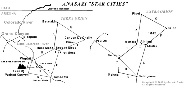
northeast, three great fingers of rock beckon. They are the three Hopi Mesas,
isolated upon this desolate but starkly beautiful landscape to which the Ancient
Ones so long ago were led. Directing our attention to the three Hopi Mesas at
the "Center of the World," we clearly see the close correlation to
Orions Belt. Mintaka,
a double star and the first of the trinity to peek over the eastern horizon
as the constellation rises, corresponds to Oraibi
and Hotevilla
on Third (Western) Mesa. The former village is considered the oldest continuously
inhabited community on the continent, founded sometime in the early twelfth
century. As recently as 1906, the construction of the latter village proved
to be a prophetic, albeit traumatic event in Hopi history precipitated by a
split between the Progressives and the Traditionalists. About seven miles to
the east, Old Shungopovi
(referred to as Masipa in Chapter 1) at the base of Second (Middle) Mesa is
reputed to be the first village established after the Bear Clan migrated into
the region, circa A.D. 1100. Its celestial counterpart is Alnilam,
the middle star of the Belt. About seven miles farther east on First (East)
Mesa, the adjacent villages of Walpi,
Sichomovi,and
Hano
(Tewa) --the first of which was settled prior A.D. 1300-- correspond to the
triple star Alnitak,
rising last of the three stars of the Belt.
Nearly due north of Oraibi at a distance of just over fifty-six miles is Betatakin
ruin in Tsegi Canyon, while about four miles beyond is Kiet Siel ruin. Located
within the boundaries of Navaho National Monument, both of these spectacular
cliff dwellings were built during the mid-thirteenth century. Their sidereal
counterpart is the double star Rigel,
the left foot or knee of Orion. (We are conceptualizing Orion as viewed from
the front.) Due south of Oraibi about fifty-six miles (equidistant to Betatakin
in the north) is Homolovi
Ruins State Park, a group of four Anasazi ruins constructed between the
mid-thirteenth and early fourteenth centuries. These represent the irregularly
variable star Betelgeuse,
the right shoulder of Orion. Almost forty-seven miles southwest of Oraibi is
the Sinagua ruin of Wupatki
National Monument, along with a few smaller surrounding ruins. Built in
the early twelfth century, their celestial correlative is Bellatrix,
a slightly variable star forming the left shoulder of Orion. About fifty miles
northeast of Walpi is the mouth of Canyon
de Chelly National Monument. In this and its side Canyon del Muerto a number
of Anasazi ruins dating from the mid-eleventh century are found. Saiph,
the triple star forming the right foot or knee of Orion, corresponds to these
ruins, primarily White House, Antelope House, and Mummy Cave. Extending northwest
from Wupatki/Bellatrix, Orions left arm holds a shield over numerous smaller
ruins in Grand Canyon National Park, including Tusayan near Desert View on the
south rim. Extending southward from Homolovi/Betelgeuse, Orions right arm
holds a nodule club above his head. This club stretches across the Mogollon
Rim and down to other Sinagua ruins in the Verde Valley region. The head
of Orion is formed by the Sinagua ruins at Walnut
Canyon National Monument and a few smaller ruins in the immediate region,
and correlates to the small triangle formed by Meissa at its apex and by Phi1
and Phi2 Orionis at its base.
If we conceptualize Orion not as the rectangle mentioned in the previous chapter
but as a polygon of seven sides, more specifically an hourglass (again recalling
Chronos of the previous chapter) appended to another triangle whose base rests
upon the constellations shoulders, the relative proportions of the terrestrial
Orion coincide with amazing accuracy. The apparent distances between the stars
as we see them in the constellation (as opposed to actual light-year distances)
and the distances between these major Hopi village or Anasazi/Sinagua ruin sites
are close enough to suggest that something more than mere coincidence is at
work here. For instance, four of the sides of the heptagon (A.
Betatakin to Oraibi, B. Oraibi to Wupatki, C. Wupatki
to Walnut Canyon, and F. Walpi to Canyon de Chelly) are exactly
proportional, while the remaining three sides (D. Walnut Canyon
to Homol'ovi, E. Homolovi to Walpi, and G. Canyon
de Chelly back to Betatakin) are slightly stretched in relation to the constellation--
from ten miles in the case of D. and E. to twelve
miles in the case of G. (See Diagram 1. To view this and Diagram
2 more easily, drag right side of navigation frame over to the left.)
 |
Diagram
1
This variation could
be due either to cartographic distortions of the contemporary sky chart in relation
to the geographic map or to ancient misperceptions of the proportions of the
constellation vis-à-vis the landscape. Given the physical exigencies for building
a village, such as springs or rivers, which are not prevalent in the desert
anyway, this is a striking correlation, despite these small anomalies in the
overall pattern. As John Grigsby says in his discussion of the relationship
between the temples of Angkor in Cambodia and the constellation Draco, If this
is a fluke then its an amazing one.... There is allowance for human error in
the transference of the constellation on to a map, and then the transference
of the fallible map on to a difficult terrain over hundreds of square kilometers
with no method of checking the progress of the site from the air.5
In this case we are dealing
not with Hindu/Buddhist temples but with multiple star cities sometimes separated
from each other by more than fifty miles. Furthermore, we have suggested that
the map is actually represented on a number of stone tablets (which will be
discussed in greater depth in the Chapter 5), and that this geodetic configuration
was influenced or even specifically determined by a divine presence, viz., Masauu,
Hopi god of earth and death.
Referring once more to Diagram 1, we also note the angular correspondences of
Orion-on-the-earth to Orion-in-the-sky. Here again the visual reciprocity is
startling enough to make one doubt that pure coincidence is responsible. Using
Bersoft Image Measurement
1.0 software, however, we can correlate in degrees the precise angles of this
pair of digital images seen in the diagram. (Note: The celestial image is drawn
from Skyglobe 2.04.)
|
Angle
|
Degrees
|
Difference
|
| AG Terra |
65.37
|
|
|
AG Orion
|
71.19
|
5.82
|
|
BC
Terra
|
132.60
|
|
|
BC
Orion
|
130.77
|
1.83
|
| CD Terra |
84.31
|
|
| CD Orion |
100.07
|
15.76
|
| DE Terra |
97.79
|
|
| DE Orion |
95.65
|
2.14
|
| FG Terra |
56.17
|
|
| FG Orion |
64.23
|
8.06
|
The closest correlation is between the left and right shoulders (BC and DE respectively) of the terrestrial and celestial Orions, with only about two degrees difference between the two pairs of angles. In addition, the left and right legs (AG and FG respectively) are within the limits of recognizable correspondence, with approximately six to eight degrees difference. The only angles that vary considerably are those that represent Orion's head (CD), with over fifteen degrees difference between terra firma and the firmament. Given the whole polygonal configuration, however, this discrepancy is not enough rule out a generally close correspondence between Orion Above and Orion Below.
Another factor
that precludes mere chance in this mirroring of sky and earth is the angular
positioning of the terrestrial Orion in relation to longitude. As previously
mentioned, the Hopi place importance upon intercardinal (i.e., northwest, southwest,
southeast, and northeast) rather than cardinal directions. Of course, the Anasazi
could not make use of the compass but instead relied upon solstice sunrise and
sunset points on the horizon for orientation. The Sun Chiefs (in Hopi, tawa-mongwi)
still perform their observations of the eastern horizon at sunrise from the
winter solstice on December 22 (azimuth 120 degrees) through the summer solstice
on June 21 (azimuth 60 degrees), when the sun god Tawa makes his northward journey.
On the other hand, they study the western horizon at sunset from June 21 (azimuth
300 degrees ) through December 22 (azimuth 240 degrees), when he travels south
from the vicinity of the Sipapuni (located on the Little Colorado River
just over four miles upstream from its confluence with the Colorado River) to
the San Francisco Peaks in the southwest.6
A few days before and after each solstice Tawa seems to stop (the term solstice
literally meaning the sun to stand still) and rest in his winter or summer
Tawaki, or house. In fact, the winter Soyal ceremony is performed in
part to encourage the sun to reverse his direction and return to Hopiland instead
of continuing south and eventually disappearing altogether.
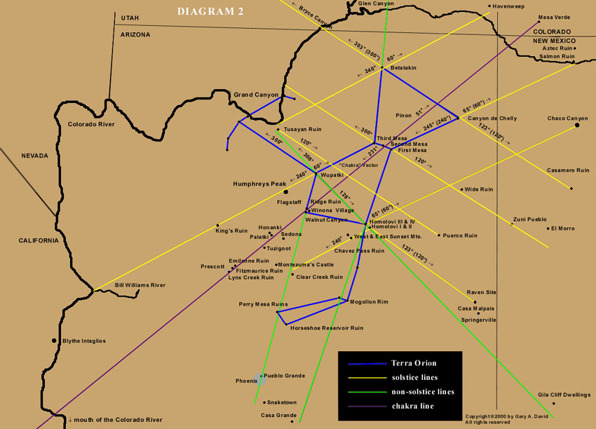
At any rate, the
key solstice points on the horizon that we designate by the azimuthal degrees
of 60, 120, 240, and 300 (that is, at this specific latitude) recur in the relative
positioning of the Anasazi sky cities. For instance, if we stand on the edge
of Third Mesa near the village of Oraibi on the winter solstice, we can watch
the sun set exactly at 240 degrees on the horizon, directly in line with the
ruins of Wupatki almost
fifty miles away. The sun disappears over Humphreys Peak, where the major shrine
of the katsinam (or kachinas) is located. Incidentally, if this
line between Oraibi and the San Francisco Peaks is extended southwest, it intersects
the small pueblo called Kings Ruin in Big Chino Valley, a stop-off point on
the major trade route from the Colorado River.7
(See Diagram 2.) If the line is extended farther southwest, it intersects the
mouth of Bill Williams River on the Colorado. Conversely, if we stand at Wupatki
on the summer solstice, we can see the sun rise directly over Oraibi on Third
Mesa at 60 degrees on the horizon. On that same day the sun would set at 300
degrees, to which the left arm of the terrestrial Orion points. In addition,
from Oraibi the summer solstice sun sets at 300 degrees, twelve degrees north
of the Sipapuni on the Little Colorado River, the "Place of Emergence"
of the Hopi from the Third to the Fourth Worlds.
 |
Diagram
2
After going east,
if we were to perch on the edge of Canyon de Chelly and not look downward into
the canyon but instead gaze southwest at the winter solstice sunset, the sun
on the horizon would appear about five degrees south of the First Mesa Village
of Walpi. If this line were extended farther southwest beyond the horizon, it
would intersect both Sunset Crater and Humphreys Peak. Again, the reciprocal
angular relationship between the two pueblo sites remains, so from Walpi at
summer solstice sunrise the sun would appear to rise from Canyon de Chelly fifty
miles away. A northeastward extension of this 65 degree line would eventually
reach a point in New Mexico near Salmon
Ruin and Aztec Ruins National
Monument.8 In
addition, a winter solstice sunrise line (120 degrees) drawn from Walpi past
Wide Ruin traverses the Zuni
Pueblo (a tribe culturally through not linguistically related to the Hopi)
and ends just south of El Morro
National Monument.9
Standing during
winter solstice sunrise on the edge of Tsegi Canyon in which Betatakin and Kiet
Siel ruins are located, we could look southeast along the northern edge of Black
Mesa and watch the sun come up over Canyon de Chelly and Canyon del Muerto.
In fact, the sun would be at 120 degrees on the horizon directly over Antelope
House Ruin in the latter canyon. An extension of the same line into New Mexico
would intersect Casamero Ruin.10 Later
on that first day of winter from the same spot at Tsegi Canyon we could see
the sun set at 240 degrees azimuth over the Grand Canyon near Tusayan Ruin more
than eighty miles to the southwest. From Tsegi a summer solstice sunrise line
of 60 degrees would intersect Hovenweep
National Monument in southeastern Utah, well known for the archaeoastronomical
precision of its solstice and equinox markers. Again from Tsegi a sunset line
of 300 degrees would cross Bryce Canyon National Park and Paunsaugunt Plateau,
where nearly one hundred and fifty small Anasazi and Fremont ruins have been
identified.11
If we travel one hundred and twelve miles almost due south of Tsegi Canyon to stand at Homolovi, the summer solstice sunset would appear eight degrees south of Wupatki, which is fifty miles northwest. This line (designated as H in Diagram 1) between Homolovi and Wupatki passes between Grand Falls, an impressive cataract along the Little Colorado River, and Roden Crater, a volcanic cinder cone that artist James Turrell has turned into an immense earth sculpture, to finally end at Tusayan Ruin on the south rim of the Grand Canyon. Again, from the reciprocal village of Wupatki the winter solstice sun would rise just north of Homolovi, which is at 128 azimuthal degrees in relation to the former site. This Wupatki-Homolovi line extended southeast would pass just south of Casa Malpais Ruin and end less than ten miles south of Gila Cliff Dwellings.12
From Homolovi
a winter solstice sunrise line (120 degrees) would pass seven degrees north
of Casa Malpais13 and three degrees north
of Raven
Site Ruin14,
both north of the town of Springerville. From Homolovi at winter solstice sundown
(240 degrees), the sun passes directly through East and West Sunset Mountains,
the gateway to the Mogollon rim. This line from Homolovi proceeds past the
early fourteenth century, thousand-room Chavez Pass Ruin on Anderson Mesa (in
Hopi, Nuvakwewtaqa, mesa wearing a snow belt)15
and continues along the Palatkwapi Trail down to the Verde Valley, ending near
Clear Creek Ruin. If we extend the summer solstice sunrise line (60 degrees)
from Homolovi into New Mexico, we intersect the vicinity of Chaco
Canyon, perhaps the jewel of all the Anasazi sites in the Southwest. In
this astral-terrestrial schema Chaco corresponds to Sirius, the brightest star
in the heavens located in Canis Major. (This will be discussed further in Chapter
7.)
Thus, in this schema
each village is connected to at least one other by a solstice sunrise or sunset
point on the horizon. This interrelationship provided a psychological link between
ones own village and the people in ones sister village miles away. Moreover,
it reinforced the divinely ordered coördinates of the various sky cities come
down to earth. Not only did Masauu/Orion speak in a geodetic language that
connected the Above with the Below, but also Tawa verified this configuration
by his solar measurements along the curving rim of the tutskwa, or sacred
earth.
In addition to
the solstice alignments,
a number of intriguing non-solstice lines exists to corroborate the pattern
as a whole. As heretofore stated, an extension of the solstice line between
Oraibi and Wupatki (the Belt and left shoulder of the terrestrial Orion respectively)
would ultimately end on the Colorado River at the point where a major trail
east toward Anasazi territory began. Similarly, if the non-solstice line between
Walpi and Homolovi (the latter being Orions right shoulder) were extended,
it would intersect the wrist of the constellation and terminate within five
miles of the important Hohokam
ruin site and astronomical observatory of Casa
Grande Ruins National Monument, near the Gila River one hundred and fifty
miles away. We have also already discussed the extension of the Walpi-Canyon
de Chelly solstice line (Orions right leg) ending up at the Salmon-Aztec ruins
area. An extension of the Oraibi-Betatakin non-solstice line (Orions left leg)
would bring us to Glen Canyon National Recreation Area. Ruefully, hundreds or
perhaps even thousands of small Anasazi ruins were submerged by the construction
of the Glen Canyon Dam in 1963, and the few that remain can only be reached
by boat.
Another alignment
of ancient pueblo sites forms the grand chakra system of Orion and indicates
the direction of the flow of spiritual energy. (See the section entitled The
Head of Orion in Chapter 6 for a fuller discussion of chakras.) Drawing a line
southwest from Shungopovi/Alnilam, we pass less than five miles southeast of
Roden Crater and Grand Falls, both mentioned above. Continuing southwest the
line runs by Ridge Ruin 16, through Winona
Village 17, and into the forehead of Orion,
which is Walnut Canyon National Monument, a mid-twelfth century Sinagua ruin
located in the foothills of the San Francisco Peaks. If the line is extended
farther still, it intersects the red rock country of Sedona with its electromagnetic
vortices, passing the small but gorgeously located ruin of Palatki, Red House,
and the larger Honanki, Bear House. In the Verde Valley the newly energized
vector directly transits Tuzigoot National
Monument, a major thirteenth century Sinagua ruin of over one hundred rooms
perched on a hilltop for the probable purpose of stellar observation. (The ruins
in both Walnut Canyon and the Verde Valley will be fully discussed in Chapter
6.) The line traverses the Black Hills of Arizona, goes by the newly excavated
Emilienne Ruin 18 in Lonesome Valley,
intersects the Fitzmaurice Ruin 19 located
upon a ridge on the south bank of Lynx Creek in Prescott Valley, continues through
the small Lynx Creek Ruin at the northern base of the Bradshaw Mountains, treks
across the northern limits of the Sonoran desert, passes near the Arizona geoglyphs
20 and ultimately reaches a point just
north of the mouth of the Colorado River, perhaps the place where the ancients
migrating on reed rafts from the Third World to the Fourth entered the territory.
(See Chapter 1.) If we were to extend this line in the other direction from
Shungopovi, it would travel northeast across Black Mesa, passing just southeast
of Four Corners to finally end up at the major Anasazi sites of Mesa
Verde National Park in southwestern Colorado.
Here we have eleven both major and minor Anasazi or Sinagua ruins and one Hopi pueblo perfectly aligned over a distance of over 275 miles within the framework of the tellurian Orion. The probability that these are randomly distributed is highly unlikely and increases the possibility that Masauu (or some other agent perceived as being divine) directed their positioning.
At this point one
might ask:
Why is the template of Orion placed upon the earth at the specific angle relative
to longitude that we find it? The chakra line mentioned above, which runs
in part from Shungopovi/Alnilam (the Belt of Orion) to Walnut Canyon/Meissa
(the head of Orion) is 231 degrees azimuth in relation to Shungopovi. The azimuthal
direction of southwest is 225 degrees. Thus, the axis for the terrestrial Orion
is within six degrees of northeast/southwest. If we stood at Shungopovi shortly
after midnight nine centuries ago on December 22nd and looked southwest, we
would find the middle star of Orions Belt hovering directly above the southwest
horizon at an altitude of about 38 degrees. Specifically,
at 1:15 a.m. on December 22, A.D. 1100, Alnilam is at 231 degrees azimuth.
21 In other words, gazing from the central
star of the earthbound belt of Orion toward its head located in the foothills
of the San Francisco Peaks where the katsinam live, we would see the
celestial constellation precisely mirror the angle of the terrestrial configuration.
One might also
question the significance of this precise time when the middle star in Orion’s
Belt is at 231 degrees. At
the very moment we are watching this sidereal spectacle, one of the most sacred
ceremonies22 of the Hopi known as the
Soyal (partially discussed in the previous chapter) is taking place down in
the kiva. Just past
its meridian Orion can be clearly seen through the hatchway. This is the time
when Hotomkam [Orion's Belt] begins to hang down in the sky. Now a powerful,
barefooted figure descends the kiva ladder. He is painted with white dots which
resemble stars on his arms, legs, chest, and back. He carries a crook on which
is tied an ear of black corn, Masauus corn signifying the Above. One account
identifies him as Muyingwa, the deity of germination mentioned in Chapter 2
in connection with Masauu.23 Another
calls him Star man, ostensibly because of his headdress made of four white
corn leaves representing a four-pointed star, perhaps Aldebaran in the Hyades.24
At any rate, this person takes a hoop covered with buckskin and begins to dance.
His sun shield fringed with red horsehair is about a foot across with a dozen
or so eagle feathers tied to its circumference. Its lower hemisphere is painted
blue, its upper right quadrant is red, and its upper left quadrant is yellow.
Two horizontal black lines for the eyes and a small downward pointing triangle
for the mouth are painted on the lower half of this face of Tawa. Alexander
Stephen, who witnessed the ritual at Walpi in 1891, remarked that the Star Priest
stamps upon the sipapu (the hole in the floor of the kiva that links
it to the Underworld) as a signal to start the most important portion of the
ceremony.25 This occurs just after
1:00 a.m., the time on this date in the year A.D. 1100 (the approximate
onset of settlement on the Hopi Mesas) when Orion was at 231 degrees
azimuth.
As the dance rhythm crescendos, the Star man begins to twirl the sun hoop
very fast in clockwise rotation around the intercardinal points between two
lines of Singers, one at the north and the other at the south. With mad oscillations
(to quote A.M. Stephen) he is attempting to turn back the sun from its southward
journey. All these dances, songs, and spinning of the sun are timed by the
changing positions of the three stars, Hotomkam, overhead. Now is the time this
must be done, before the sun rises and takes up his journey.26
If this were merely a solar ritual, one would assume that it would take place
at sunrise. On the contrary, the sidereal position of Orion must reflect the
terrestrial positioning of the constellation, which only occurs after the former
has passed its meridian, i.e., ...when Hotomkam begins to hang down in the
sky. Prior to dawn runners are sent out to the shrines of both Masauu
(Orion) and Tawa (the sun) in order to deposit pahos (feather sticks),
prayer offerings to the two gods whose complex interaction helps assure the
seasons cyclic return, keeping the world in balance for yet another year.
In addition to the solstice lines, the celestial phenomenon of lunar standstill further substantiates the specific orientation of the Orion template upon the Arizona desert. Similar to the annual cycle of the sun, the moon in its monthly cycle rises and sets at different points on the horizon. However, the moon also has a longer cycle --18.6 years, to be exact-- when its rising and setting points reach extremes on the horizon. At this time in the so-called major lunar standstill cycle, the moon rises and sets 6.1 degrees north and south of the positions of the rising and setting of the summer and winter solstice suns. 27 For instance, in A.D. 1500 at 36 degrees North Latitude the moon at its extreme north excursion rose at 54º02 azimuth and set at 305º58. At its extreme southern excursion the moon rose at 126º45 and set at 233º15.28 A computer program to determine lunar standstill set for 35.48 degrees latitude (Shungopovi, Arizona) at A.D. 1100 (approximate settlement date) retrieved nearly the same results: 54.6 degrees, 305.0 degrees, 126.0 degrees, and 233.0 degrees.29
Surely the Anasazi
recognized that at certain times the moon rises and sets farther north and south
than does the sun at its most extreme points, and this fact must have caused
consternation or even awe. Indeed, we have evidence that major lunar standstills
were ritually incorporated into the architectural axes of some of the pueblos
at Chaco Canyon 30, as well as into the
design of the Sun Dagger petroglyph on Fajada
Butte.31 In addition, an outlier of
Chaco Canyon known as Chimney
Rock Pueblo in southern Colorado was specifically oriented to take into
account this phenomenon. Only at the northern extreme of this eighteen-and-a-half
year cycle would the moon rise between two great pinnacles of rock beneath which
the pueblo was built.
The most important astronomical event visible from the town may have been the spectacle of the full moon rising between the chimneys near the time of winter solstice.... The full moon always rises at sunset. When it rose between the double spires above the snow-covered landscape, colored red from the glow of the sunset, the moon must have appeared huge and brilliant. The sight of the moon rising between the chimneys ranks as one of the dramatic events in the heavens. Our Anasazi predecessors could not help but have been impressed. 32
Witnessing a variation of the same phenomenon from the Hopi Second Mesa (the middle star in the terrestrial Belt of Orion), they may have been equally impressed by the rising moon over the snow-dusted foothills of the San Francisco Peaks nearly seventy miles away-- the place where the pueblos in Walnut Canyon (the heard of Orion) are located. For instance, on December 21st of A.D. 1112 the sun set as usual about 5:00 p.m. at its farthest point south on the western horizon, i.e., 240 degrees. Forty-five minutes later the slender sliver of a waxing moon hung on the same horizon at 233 degrees azimuth-- even farther south than the sun had set. This must have given sky watchers cause for some concern.
As previously stated,
the chakra line from Shungopovi to Walnut Canyon is 231 degrees azimuth, two
degrees less than the setting of the moon at its southern extreme. Going the
opposite direction, the line from Shungopovi to Mesa Verde is at 51 degrees
azimuth, three degrees less than the rising moon at its northern extreme (54º02).
The left-to-right-shoulder line from Wupatki to Homolovi (H in
Diagram 1) crosses the chakra line to form a Latin cross. (Also see Diagram
2.) The azimuth of this line is 128 degrees, less than a two degrees difference
from the rising moon at its southern extreme (126º45). Going in the opposite
direction, i.e., from Homolovi to Wupatki, we find an azimuth of 308 degrees,
less than a three degrees difference from the setting moon at its northern extreme
(305º58). These discrepancies may be the result of the astronomical phenomenon
that causes the moon to appear larger on the horizon than when its altitude
is greater. When the moon is high in the sky it takes up about one-half of one
degree (as does the sun, coincidentally), but because of atmospheric conditions
it might appear twice its actual size or more as it rises or sets. A number
of factors, such as parallax and atmospheric refraction, can shift and broaden
the range of azimuth where risings and settings of the solstice suns and the
standstill moons appear on the horizon. 33
The larger appearance of the moon on the horizon could plausibly account for
the two to three degrees difference between the lunar standstill points and
the azimuths of both the chakra line and the perpendicular Line H.
If this is the case, not only is Terra Orion positioned via a variety of solstice
lines, but it is also affixed to the landscape seemingly in accordance with
the moons most extreme positions on the horizon.
Given that the head of the celestial constellation points north throughout the night, one might question why the terrestrial Orion is oriented toward the south. An answer to this can be found in the schema of Hopi cosmology discussed in Chapter 2. The subterranean realm of ancestral spirits is putatively an exact replica of the pueblo world of physical beings, except in reverse.
While the winter fields lay fallow, residents of the underworld were said to be cultivating and harvesting crops. The harvest obtained in the underworld, good or bad, would be duplicated in this world during the fall months. Similarly, while the Hopi were celebrating the summer solstice with a relatively meager ceremony, the elaborate winter solstice rituals were underway in the underworld, and while Soyal, the Hopi winter solstice festival, was in full swing, denizens of the underworld were holding the celebration of summer. Thus, the upper and lower worlds were mirror images of each other. 34
When the Anasazi
gazed into the heavens, they were not looking at an extension of the physical
world as we perceive it today but were witnessing instead a manifestation of
the spirit world. Much like the Egyptian Duat, the Hopi Underworld encompasses
the skies as well as the region beneath the surface of the earth. This is apparent
in the dichotomous existence of ancestor spirits who live in the subterranean
realm but periodically return to their earthly villages as clouds bringing the
blessing of rain. Even though the eastern and western domains ruled by Tawa
remain constant, the directions of north and south, controlled by the Elder
and Younger Warrior Twins (sons of the Sun) respectively,
are reversed. Thus the right hand holding the nodule club is in the east and
the left hand holding the shield is in the west, similar to the star chart.
However, the head is pointed roughly southward instead of northward. This inversion
is completely consistent with Hopi cosmology because the terrestrial configuration
is seen as a reversal of the spirit world, of which the sky is merely another
dimension. Another explanation for the change of directions is the possibility
that the pole shift which destroyed the Hopis Second World reversed the position
of the constellation's mundane aspect.
At any rate, when looking up at Orion on a midwinter night, we can imagine that
our perspectives have switched and we are suspended high above the land,
gazing to the southwest toward the sacred katsina peaks and the head
of the celestial Masauu suffused in the evergreen forests of the Milky Way.
an
excerpt from Chapter 2 of The Orion Zone: Ancient Star Cities of the American
Southwest
Copyright
© 2000-2004 by Gary A. David. All rights reserved
Any
use of text or graphics without the author's prior consent is expressly forbidden.
Contact:
e-mail islandhills@cybertrails.com
Footnotes
1. Richard Maitland Bradfield, An Interpretation
of Hopi Culture (Derby, England: published by author, 1995), pp. 287-288.
2. Hamilton A. Tyler, Pueblo Gods and Myths
(Norman, Oklahoma: University of Oklahoma Press, 1964), p. 26.
3. Thomas E. Mails, The Pueblo Children of the
Earth Mother, Vol. II (New York: Doubleday & Company, Inc., 1983), p. 47.
4. Susanne and Jake Page, Hopi (New York:
Abradale Press, Harry N. Abrams, Inc., 1994, reprint 1982), pp. 217-223.
5. Grigsby cited by Graham Hancock, Santha Faiia,
Heavens Mirror: Quest For the Lost Civilization (New York: Crown Publishers,
Inc. 1998), p. 127.
6. J. McKim Malville, Claudia Putnam, Prehistoric
Astronomy in the Southwest (Boulder Colorado: Johnson Books, 1993, 1989),
p. 23.
7.
Inhabited from A.D. 1026 (or possibly earlier in light of the underlying pit
house) through 1300, King's Ruin has a thirteen room foundation, twelve of which
could have been two stories high. The five hundred pieces of unworked shells
found at the site indicate substantial trade with the Pacific. Necklaces of
turquoise, black shale and argillite were also found, one of the former material
consisting of 2,031 beads that stretched sixty-six inches long. Fifty-five graves
were also discovered, containing sixty-six individuals, most of which were buried
in the extended posture with heads oriented toward the east, awaiting Pahanas
return. Ginger Johnson, A View of Prehistory in the Prescott Region (Prescott,
Arizona: privately published,1995) pp. 8-9.
8. Occupied for a few generations after A.D. 1088,
abandoned and then reoccupied between 1225 and the late 1200s, Salmon Ruin near
the San Juan River contained from between 600 and 750 rooms. It also had a tower
kiva built on a platform twenty feet high which was made of rock imported from
thirty miles away. Ten miles north of Salmon is Aztec Ruin (an obvious misnomer)
located on the Animas River. At its peak development it contained about 500
rooms. Like the former, this latter site was originally inhabited in the early
twelfth century by people of Chaco Canyon and then re-inhabited from 1225 to
1300 by people of Mesa Verde. In addition, it has a restored Great Kiva.
9. Inhabited from A.D. 1226-1276, Wide Ruin, or
Kin Tiel, about fifty miles due south of Canyon de Chelly, is an oval shaped
pueblo of 150 to 200 rooms with a number of kivas. Atsinna pueblo, located atop
a high mesa at El Morro National Monument, was a mid-thirteenth century rectangular
structure, part of which was three stories in height. It had 500-1000 rooms
and two kivas, one circular and the other square.
a. David Grant Noble, Ancient Ruins of the Southwest: An Archaeological Guide
(Flagstaff, Arizona: Northland Publishing, 1989, reprint 1981).
b. Norman T Oppelt, Guide to Prehistoric Ruins of the Southwest (Boulder,
Colorado: Pruett Publishing Company, 1989, reprint 1981).
10. Constructed in the mid-eleventh century, Casamero Ruin was a small thirty room pueblo. However, its Great Kiva, one of the largest in the Southwest, was seventy feet in diameter-- even slightly more spacious than the better known Casa Rinconada at Chaco Canyon about forty-five miles to the north. Noble, Ancient Ruins, pp. 108-110; and Oppelt, Guide To Prehistoric Ruins, p.177.
11.
Robert H. Lister and Florence C. Lister, Those Who Came Before: Southwestern
Archeology in the National Park System (Tucson, Arizona: Southwestern Parks
& Monuments Association, 1994, reprint 1993), p. 224.
12. Located in the Mogollon Mountains of west-central
New Mexico, Gila Cliff Dwellings National Monument is a ruin comprised of forty
rooms in five separate caves located 150 feet above the canyon floor. The timbers
of these structures have been tree-ring dated in the 1280s. The late Mogollon,
or Mimbres, people are known for their exquisite black on white pottery, using
realistic though stylized designs. The site was abandoned by 1400. Noble, Ancient
Ruins, pp. 7-8.
13. Casa Malpais is a thirteenth century Mogollon
site of a hundred rooms with a square Great Kiva (one of the largest in the
Southwest), catacombs,
ceremonial rooms, three winding stone stairways and an astronomical observatory.
Because of the nature of the artifacts found, such as crystals, ceremonial pipes,
and soapstone fetish stands, it is thought to have been primarily a religious
center. Stan Smith, House of the Badlands, Arizona Highways, August,
1993, pp. 39-44.
14. Located nearly ninety miles southeast of Homolovi and about twelve miles north of the Casa Malpais, the Raven Site (privately owned by the White Mountain Archeological Center) was occupied as early as A.D. 800 through A.D.1450 and had more than eight hundred rooms and two kivas. James R. Cunkle, Raven Site Ruin: Interpretive Guide (St. Johns, Arizona: White Mountain Archaeological Center, no publication date).
15. Jefferson Reid and Stephanie Whittlesey, The Archaeology of Ancient Arizona (Tucson, Arizona: The University of Arizona Press, 1997), p. 220.
16.
Occupied from A.D. 1085-1207, Ridge Ruin was a thirty room pueblo with three
kivas and a Maya-style ball court was the site of the so-called Magicians Burial.
Thought by Hopi elders to be of the Motswimi, or Warrior society, this apparently
important man was interred with twenty-five whole pottery vessels and over six
hundred other artifacts, including shell and stone jewelry, turquoise mosaics,
woven baskets, wooden wands, arrow points, and a bead cap.
a. Rose Houk, Sinagua: Prehistoric Cultures of the Southwest (Tucson,
Arizona: Southwest Parks & Monuments Association, 1992), p. 7.
b. Oppelt, Guide to Prehistoric Ruins, pp. 99-100.
c. Reid and Whittlesey, Archaeology of Ancient Arizona, pp. 219-220.
17. The eponymous Winona Village, which was occupied at the end of the 11th century, contained about twenty pit houses and five surface storage rooms. Oppelt, Guide To Prehistoric Ruins, p. 99.
18.
The Emilienne Ruin had a foundation of twelve rooms, most of which could have
been two stories high, plus eleven outlying one-room units.
19. The Fitzmaurice Ruin, occupied from A.D. 1140-1300,
had twenty seven rooms in which were found beads, pendants, bracelets, and eighty
one amulets, including crystals, animal fetishes, obsidian nodules (so-called
Apache Tears) and a curious six-faceted, truncated pyramid carved from jadeite
and measuring 1.5 centimeters wide.
a. Franklin Barnett, Excavation of Main Pueblo At Fitzmaurice Ruin: Prescott
Culture in Yavapai County, Arizona (Flagstaff, Arizona: Museum of Northern
Arizona, 1974), p. 95.
b. Johnson, Prehistory in the Prescott Region, p. 16.
20. Similar to the Nazca lines of Peru, these intaglios of human, animal, and star figures, some over a hundred of feet long, were made by removal of the darker, desert varnished pebbles, exposing the lighter soil beneath. Reid and Whittlesey, Archaeology of Ancient Arizona, pp. 127-129. According to the Mohave and Quechan tribes of the lower Colorado River region, the human figures represent the deity Mastamho, the Creator of the Earth and all life. Notice the similarity between the name of this god and that of the Hopi earth god Masauu. These figures are thought to be between 450 and 2000 years old.
21. Also at 1:15 a.m. on this date Bellatrix is at 240 degrees azimuth and Meissa is at 242 degrees azimuth. Forty minutes later Alnilam is at 240 degrees, the azimuthal degree at which the sun will set at 5:15 p.m. on this same day. Incidentally, at this winter solstice sunset time Orion is just rising on the opposite horizon, thus emphasizing the pivotal relationship of Orion/Masauu and the Sun/Tawa.
22. Edmund Nequatewa cited by John D. Loftin, Religion and Hopi Life In the Twentieth Century (Bloomington, Indiana: Indiana University Press, 1994, reprint 1991), p. 33.
23. Frank Waters and Oswald White Bear Fredericks, Book of the Hopi (New York: Penguins Books, 1987, reprint, 1963), pp. 158-161.
24. Bradfield, An Interpretation of Hopi Culture, pp. 134-135.
25. Stephen cited by Ray A. Williamson, Living the Sky: The Cosmos of the American Indian (Norman, Oklahoma: University of Oklahoma Press, 1989, reprint 1984), pp. 79-82.
26. Waters and Fredericks, The Book of the Hopi, pp. 161-162.
27.
Anna Sofaer, The Primary Architecture of the Chacoan Culture: A Cosmological
Expression, Anasazi Architecture and American Design, edited by Baker
H. Morrow and V.B. Price (Albuquerque, New Mexico: University of New Mexico
Press, 1997), p. 98
28. Ray A. Williamson, Living the Sky: The Cosmos
of the American Indian (Norman, Oklahoma: University of Oklahoma Press,
1984), p. 40.
29.
Calculating the declination and azimuth [online] Victor Reijs and His BBS
Geniet, 1996 [cited 26 September 2000]. Available from the World Wide Web:
30.
Anna Sofaer, Anasazi Architecture, pp. 96-120.
31. Anna P. Sofaer and Rolf M. Sinclair, Astronomy
and Ceremony in the Prehistoric Southwest, John B. Carlson and W. James
Judge, editors (Maxwell Museum of Anthropology, Anthropological Papers, No.
2, 1983).
32. Malville and Putnam, Prehistoric Astronomy in the Southwest, p. 51.
33.
Anna Sofaer, Anasazi Architecture, p. 98.
34. Malville and Putnam, Prehistoric Astronomy
in the Southwest, p. 25.
![]()